


Below you will find all New York subway and bus maps for 2026, for each of the boroughs of New York. The maps are from the MTA (Metropolitan Transportation Authority). The MTA is a company that is responsible for all public transportation in New York City.
Eric's Index
Download your MTA New York Subway and Bus Maps
You can download the maps as PDFs by clicking on the buttons below. You can then save them and use them when you travel to New York.
New York Subway MapManhattan Bus MapBrooklyn Bus MapBronx Bus MapQueens Bus MapStaten Island Bus MapStaten Island Express Bus Map
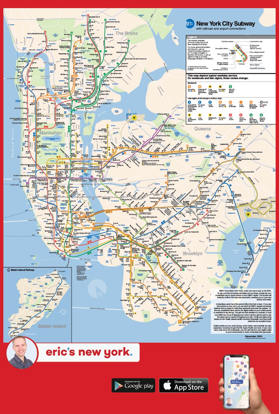
How to use the New York subway map
There’s a lot to see and read from the free subway map for New York. I’ll highlight the most important things:
- Every subway line has a distinct color and a number or letter.
- The numbers and letters that you see with every station are the subway trains that stop there.
- Bold numbers/letters mean all day service, 7 days a week. Regular numbers/letters mean limited or weekday-only service.
- Black dots indicate local-only stops, whilst white dots show express stations. Local trains stop at every station, while express trains skip some stops, which makes them faster.
And don’t be confused about the geography, the MTA map isn’t perfectly to scale or aligned with actual street grids. Its primary purpose is to show you the subway lines, stations, and transfer points in a clear way.
Offline New York Map
If you would like to navigate the Big Apple offline, I would recommend downloading my free app. Here you will be able to see all of the subway lines and stops in the city. I update the app regularly, so all information is up to date.
New York subway accessibility map
Not all New York subway stations have elevators or are wheelchair accessible. On the New York Subway Map you can find which subway stations are wheelchair accessible.
Accessible Subway StationsLIRR New York and Metro-North map
Long Island Rail Road (LIRR) in New York is a train network that connects Manhattan with Brooklyn, Queens and the entire Long Island. MNR stands for Metro-North Railroad and is a train network that connects New York City with upstate New York.
Train Network New York MapIf you have any questions about public transport in New York, please do not hesitate to contact me.